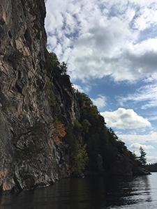
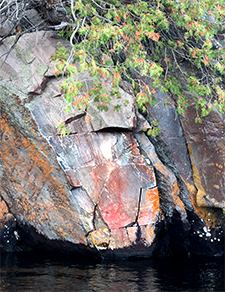
The Mazinaw escarpment is majestic and intimidating 330 feet high, and just above the waterline are over 200 pictographs painted in red ochre across 65 rock faces spanning one mile (1.5 km).1
Most of the paintings are at the cliff base with the most impressive of the pictographs being relatively close together along a 100-foot stretch, some of them were painted high on the cliff and inaccessible. To see the waterline paintings you need to get up close and personal. From a distance, they become indistinguishable because of the surrounding orange lichen that grows on the rock.
Mazinaw means “Painted Rock” in Algonkian
The escarpment is fascinating with clearly defined strata of granite and black dykes. During thunderstorms over the lake, the rock face collects and reflects the sound into a “Bon Echo”. It’s a natural canvas and dramatic setting for the pictographs. No doubt the original Algonquin artists or shaman knew this when they chose the spot, it may have held some spiritual significance.
These pictographs take many forms, from abstract and geometric shapes to representations of people and animals. The Mazinaw Rock paintings are more complex than many other sites2, not only do the paintings range from the basic shapes and representations, but they also incorporate scened stories and mythology featuring spiritual figures.
 How old are they?
Who knows. Pictographs that are outside of caves have to survive the ravages of the sun, wind, and rain. What ends up staying on the rock is the staining left behind from the red pigment, making dating the pictographs difficult. The timeframe of the paintings may span from 1,500 to 150 years ago. It’s unconfirmed but rumoured to be one of the oldest rock art sites on the Canadian Shield.
Access to the site
Get there the same way the Algonquin ancestors did – by canoe! All the paintings along the waterline were done from canoes. During the time these pictographs were painted, tools and other items may have dropped into the lake. On January 27th, 2018 a team of divers from PTO Exploration made the world record for the deepest dive under ice (at 433 feet)3, It was their first dive, and while they didn’t find anything this time, my fingers are crossed for them for next time.
“There could be clay pipes, tobacco offerings and other artifacts that slipped into the water and sunk to the bottom around the time the pictographs were drawn.”
~ Kevin Brown
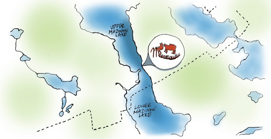
 Visit the Mazinaw Lake Pictographs, a National Historic Site of Canada, in Bon Echo Provincial Park, just north of Cloyne south-central Ontario, Canada. The pictographs are situated on the southeastern shore of Mazinaw Lake.
1 “Mazinaw Rock”, wikipedia.org https://en.wikipedia.org/wiki/Mazinaw_Rock
2 Canada’s Historic Places “Mazinaw Pictographs National Historic Site of Canada” http://www.historicplaces.ca/en/rep-reg/place-lieu.aspx?id=10534&pid=0
3 CBC News “Local divers say they set world record for deepest ice dive” Jan 29, 2018, http://www.cbc.ca/news/canada/ottawa/divers-smash-ice-dive-record-1.4509143